
Courmayeur piste ski map
Located on the Italian side of the Mont Blanc massif, Courmayeur is one of the most scenic ski resorts in the Alps, offering a mix of 100 km of pistes and extensive off-piste terrain. The ski area is spread across two main sectors (Chécrouit and Val Vény) each with a distinct terrain profile and orientation. Known for its sunny slopes, tree-lined descents and panoramic views of Mont Blanc, Courmayeur combines traditional alpine charm with modern lift infrastructure. The ski area reaches up to 2,755 m at Cresta d’Arp, offering strong vertical skiing and access to renowned freeride routes such as Toula and Vallée Blanche.
Below you can download the latest Courmayeur piste maps in PDF format to help you understand how the different sectors of the ski area connect. Further down the page, you’ll also find helpful information about the best ski pistes in Courmayeur by ability level.
Courmayeur piste ski map
Click on the link below to download the latest
The Courmayeur ski area spreads across two distinct mountain sides. The Chécrouit sector, which is south-facing, and the Val Vény sector, on the north-facing side, which is quieter and more sheltered, with colder snow conditions and tree-lined runs. Below you can view and download the piste maps for each sector individually.
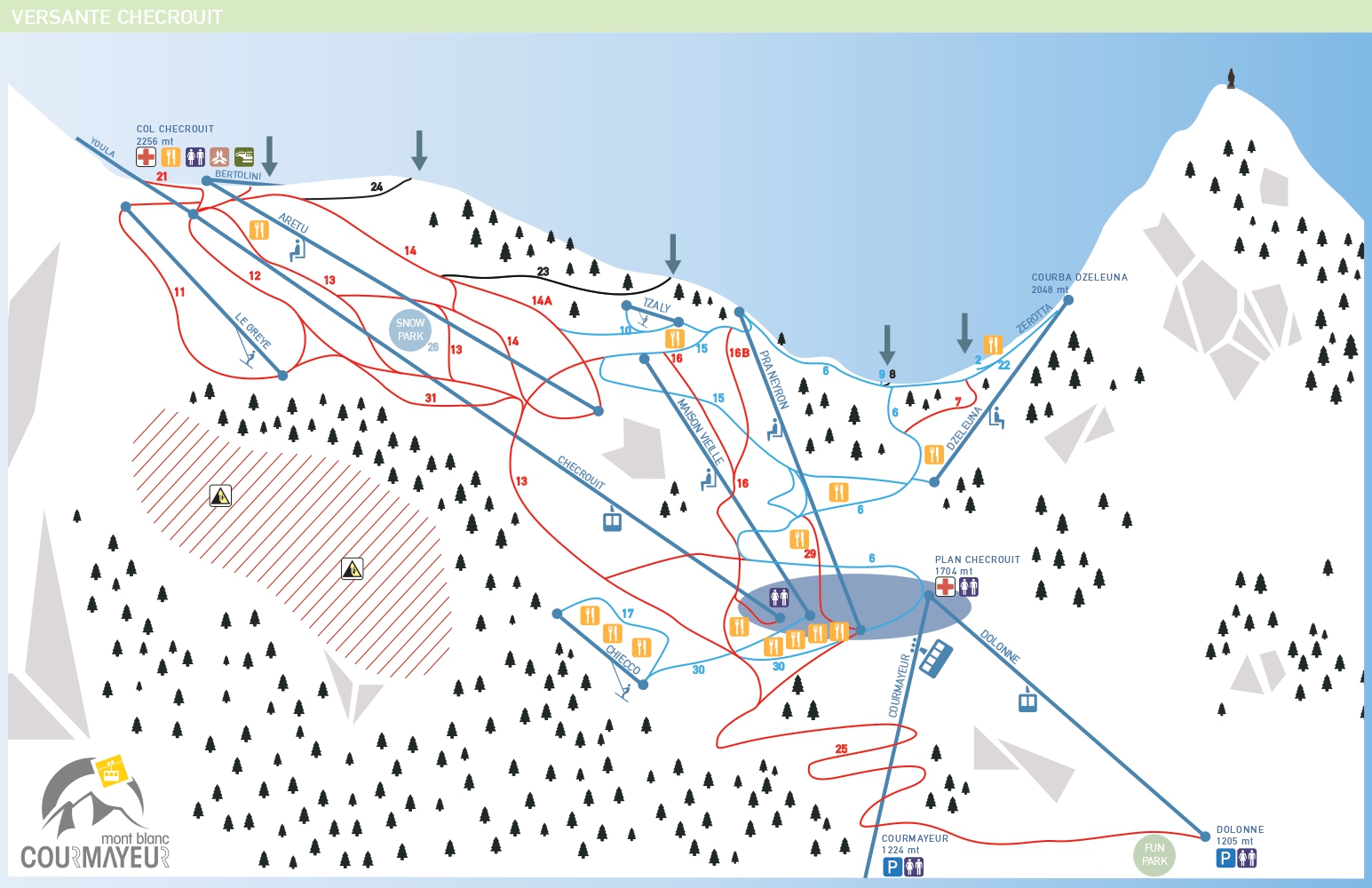
Courmayeur Chécrouit piste ski map
The Chécrouit sector is the main skiing area of Courmayeur, located above the resort and accessed via the primary lift system. This side of the mountain is known for its wide, open slopes with direct views of Mont Blanc, a mix of red and blue pistes suitable for most skiers and key lift hubs such as Plan Chécrouit and Maison Vieille.
Courmayeur Val Vény piste ski map
The Val Vény sector offers a quieter and more natural skiing experience, located on the opposite side of the mountain. This area is characterised by tree-lined slopes and more sheltered terrain, excellent snow preservation and access to freeride routes and less crowded pistes.
Courmayeur ski slopes
- To beginner skiers Courmayeur offers a limited but well-designed selection of ski terrain, mainly located around the mid-mountain. Lazey is one of the most accessible blue runs, offering gentle gradients and smooth terrain, ideal for progression.
- Intermediate skiers will find the best terrain across both sectors, with long and scenic red and blue runs. Maison Vieille is a classic red piste offering flowing turns and panoramic views. Rocce Bianche provides a quieter and more relaxed descent, while Col Checrouit to Zerotta allows for long top-to-bottom skiing across the mountain.
- Advanced and experienced skiers can explore steeper terrain and some of the best freeride routes in the Alps. Arp provides access to high-altitude descents and ungroomed terrain, while Diretta offers a steep and technical challenge. For off-piste skiing, Courmayeur is a gateway to legendary routes such as: Toula Glacier and Vallée Blanche (towards Chamonix).
Courmayeur Mont Blanc ski resort overview
- Kilometres of ski pistes: 100 km
- Number of ski pistes: 33
- Types of ski pistes: 11 blue, 17 red, 5 black
- Base elevation: 1,224 m
- Highest lift: 2,755 m
- Vertical drop: approx. 1,545 m
- Longest run: 8,5 km (Arp to Dolonne)